The Washington Backcountry Discovery Route (WABDR) is a 593-mile path from Oregon to British Columbia. It is one of eleven backcountry discovery routes (BDRs) well-loved by the off-roading community. This off-road trail winds through the majestic Cascade Mountains in the foothills of Eastern Washington and is suitable for 4WD automobiles, dual-sport motorcycles, and mountain bikes.
The Washington Backcountry Discovery Route is an exhilarating riding experience that entails dirt driving, temperature fluctuations, and encroaching wildfires. On route, you will discover stories behind historical sites and the local communities along the western slopes of the Cascade Mountains.
Many of the roads along the Washington Backcountry Discovery Route are in remote areas and reach high elevation where road maintenance is minimal. Expect to be challenged with roads covered with deep ruts, loose rocks, sand, steep grades, and rough surfaces.
You may also encounter fallen trees or branches. But more than riding conditions, WABDR also brings you back in time – telling you the story of old Washington with its historic mining outposts and granite remnants of the China Wall. It’s not the Rubicon Trail, but there’s much more to this route than meets the eye.

Washington Backcountry Discovery Route: A Truly Great Expedition
Bryce Stevens and Andrew Cull won the 2010 Overland Flag competition for their proposal to create this off-road route. Two Toyota 4×4 trucks, a Land Cruiser, and an FJ Cruiser set out for the seven-day expedition. They scouted the track based on the team’s study of detailed maps and linkage between unpaved public roads and a few paved sections.
These trailblazers also teamed up with Tom Myers and Paul Guillien from Touratech-USA, Helge Pedersen from GlobeRiders, and Sterling Noren from Noren Films. The other teams rode BMW and KTM adventure bikes equipped with tons of Touratech equipment, followed by a support driver in a 4×4 truck.
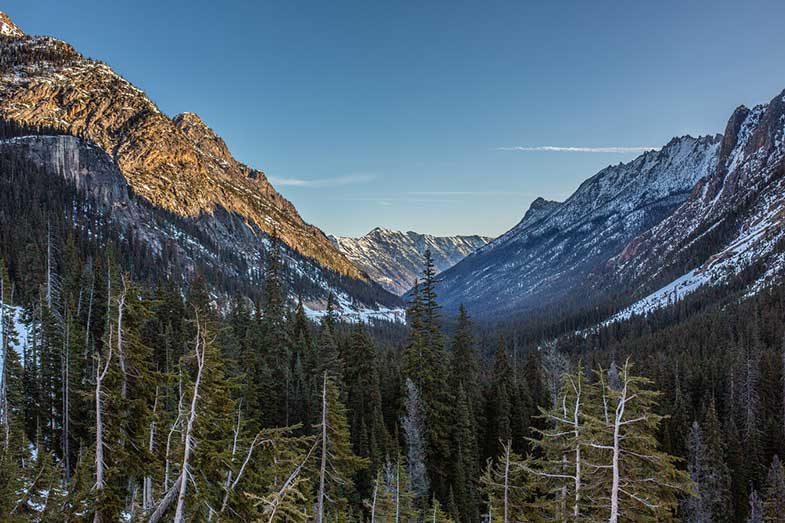
The overall length of this trail is 593 miles if you begin in Oregon. It goes through the Cascade Mountains up to the Canadian border. The southern part of the route showcases Washington’s diversity with stunning views of massive volcanic mountains, while the central part features open arid pine forests.
The road builds up its appeal the longer you ride. Views and terrain get better each day as you head into the high-mountain areas beyond Lake Chelan.
Symbolic Beginning
The first section of the route involves crossing the Bridge of the Gods, which is the official southern end of the Washington Backcountry Discovery Route. Here, you can fuel up for the long trip to Packwood. You’ll also find several groceries, restaurants, and lodging options in town – among them the highly-recommended Walking Man Brewery.
The route goes northeast over Triangle Pass and Trail Peak on gravel and dirt roads. It heads through the Gifford Pinchot National Forest, providing a great view of Mt. Hood, Mt. Adams, and Mt. St. Helens, all of which lost 1,300 feet of elevation due to a massive eruption in 1980.
While in this part of the trail, riders never miss visiting the Guler Ice Caves located west of Trout Lake, near Peterson Prairie Campground. It was created by a lava flow over 20,000 years ago, preserving ice formations year-round.
After this detour, the route continues over Grand Meadows, Takh-Takh Meadows (where Takhlakh Lake is situated nearby), Midway Meadows, and then Highway 12. There you can enjoy other scenic views and rugged pathways. The entire section distance is 120 mi / 192 km.
Trails of Ellensburg
It is the longest of the six checkpoints of the Washington Backcountry Discovery Route (and the most difficult, according to riders), stretching 123/195 km. From Highway 12, the route crosses over White Pass and adjoins Rimrock Lake before turning north up to Bethel Ridge.
Resorts in both places have several campgrounds and cabins open year-round. They also have restaurants, gas stations, grocery stores (with camping supplies), and deli food.
Beyond this point, the rocky section gives a preview of what riders should anticipate at Baby Head Hill, which is known for its steep ascents. A basalt ridge dropping off sharply to the Tieton River Valley provides spectacular views of Mt. Rainier and Mt. Adams.
A long descent then brings you to Highway 410 near Nile and a dirt road heading up over Cleman Mountain. It passes through the Oak Creek Wildlife Area and then goes down Evans Canyon. The descent continues past Old Durr Road until a short paved portion leads you over the Umtanum Ridge.
WABDR Section 3
This 77 mi (124 km) section crosses Interstate 90 at Exit 106 on Ellensburg’s outskirts. Paved roads head north from Reecer Creek toward Table Mountain and Lion Rock Lookout in Wenatchee National Forest. Its views of the Central Cascade Mountains make this a delightful section.
The route from Lion Rock to Beehive Reservoir is stunning as it is rugged and remote. It is also a great spot to rest and take captivating photos of the Ellensburg at night. The route at 6,000 feet along Table Mountain offers views to the west.
The road crosses a ridgeline with fantastic views of the Devil’s Gulch and the Columbia River. The route then descends into the Mission Creek Valley to the town of Cashmere, which has gas stations, groceries, restaurants, and hotels.
There is also a truck stop where off-roaders can shop for provisions, grab a bite, and stay in a hotel. Cashmere has all the services you need before heading up Nahahum Canyon toward the Entiat Mountains.
View from the Clouds
One of the best summits of this journey is Nahahum Canyon (pronounced Nah-Hum), where you can find a 360° view atop Chumstick Peak with an elevation of 5,810 feet. This 104-mile (167 km) route goes over Roaring Ridge in the Entiat Mountains before descending steep switchbacks to Ardenvoir.
Ardenvoir is a small town with a cafe, gas stations, and supplies. Make sure to break for food and fill up gas. You can also check out the Steliko Lookout Tower right above the town.
The next 30 miles will gain you an elevation of over 4,000 feet as you climb McKenzie Ridge and the Chelan Mountains. Get a much-deserved rest and take a dip at Lake Chelan, or enjoy its views as you pass through the Slide Ridge area going to 25 Mile Creek State Park. Then follow the southern Lake Chelan shoreline via a paved road to the full-service town of Chelan.
Before the Finish Line
This 103-mile (166 km) route ascends north from Lake Chelan past the Echo Valley Ski Area toward the 5,867-foot Cooper Mountain. From Cooper Mountain, the route then continues past Black Canyon Creek and skirts Fox Peak before going down to the Gold Creek Valley, the Methow River, and eventually Highway 153.
Here, you will pass Carlton before heading east on Benson Creek Road. The path goes up past Thrapp Mountain and Woody Mountain before descending again into to Highway 20.
After that short highway section, you are back on dirt roads heading to beautiful Loup Loup Canyon Road. Here, you can find tall granite stones and evidence of the old mining operations from the late 1800s.
The steep Ruby Grade (once the center of commerce in the Okanogan area until the silver market collapsed in the 1900s) is also found here and descends toward a site where Ruby’s mining town once existed. After this, gravel and paved roads take you to Conconully, which has a motel, stores, a gas pump, lakes, and a state park.
Beyond the Border
Finally, we’re down to the shortest section of the six checkpoints of Washington Backcountry Discovery Route. It involves a distance of 66 mi/107 km. From Conconully, the pavement eventually turns back to dirt roads as riders reach Salmon Meadows in the Okanogan National Forest. Enjoy the scenery as you go up Lone Frank Pass (the highest point on the WABDR), which crests a ridge at about 6,700 feet.
Afterward, the route enters Loomis State Forest and up Skull and Crossbones Road, where you can see an old homestead cabin and corral. You can say it is also the last hurrah for riders who want to spend their last night on the WABDR. It’s a great campsite where they can relax and stargaze before heading down to North Fork Toats Coulee Creek.
The pioneers originally stashed a geocache in the hilltop clearing at Cold Creek Camp and Viewpoint. Now, it is located near the viewpoint above Cold Springs Campground up Ninemile Creek Road. There are fuel and provisions in Loomis before reaching this part of the last section. Oroville is another town you can go to near the north end of the Washington Backcountry Discovery Route for more services.
The route then winds down steep switchbacks into a spectacular valley just south of Palmer Lake in the Sinlahekin Valley. Most of the dirt and gravel will be behind you as you go past Palmer Lake through the Nighthawk border crossing from the U.S. into Canada. It would be the northern endpoint of the WABDR. If you don’t want to end just yet, a short side trip leads to two lakeside campgrounds popular with fishermen – one DNR and the other BLM-managed.
The Chopaka U.S.-Canadian Border crossing is the official northern end of the WA Backcountry Discovery Route. You’ve made it! Take it all in, and let the scenery sink into your memory, as taking photos near the crossing is prohibited.
Interest Points along the WABDR
There are numerous side trips and resting spots across the six sections of the WABDR. If you need more detailed information, check out the BDR website. You should find recommendations on where to gas up, eat, and spend the night while en route to Canada (or to Washington, if you started from the north).
Some of these areas offer essential services and campsites, while others have restaurants and hotels. Additionally, there are tons of viewpoints and lakeside campgrounds along the way. You can stop to admire the wilderness or cool off from the heat amid nature. Some great spots to visit are Babyshoe Ridge Viewpoint, Horseshoe Lake, Cash Prairie Camp, Winthrop, and Leader Lake.
For Motorcycles
Because it is double-track, the WABDR lures in dual-sport bikers. Experts would do fine with any section of the 593-mile road. It is best for new adventure-type riders to start at Section 1 (Stevenson to Packwood) or Section 6 (Conconully to Canada). Avoid attempting Section 2 (Packwood to Ellensburg) if you plan to cover only one section of the trail. Furthermore, avoid riding alone. Either join group rides or organize your own.
Use good-quality off-road tires, such as TKC-80 or Dunlop-606 knobby tires. If you plan to cover only one section of the trail, don’t fill up your gas tank as it makes the bike very top-heavy. Also, set your bike up for comfort when riding standing up. Your setup should include hand and foot control adjustments, handlebar risers, and wide pegs, to name a few.
For Jeeps and Other 4WD Vehicles
Veterans advocate Section 2 for 4×4 vehicle owners who want to get the most out of the WABDR. After all, it is considered the Washington Backcountry Discovery Route Jeep trail. However, it doesn’t matter if you plan to cover only a portion of the entire track or decide to have a full-on six-day tour and the lush forests of the Cascade Mountains. Contrary to popular belief, it is not WABDR Section 3, but Section 2, which has proven to be the toughest part of the BDR route.
Before embarking on the WABDR, pack everything that you need for the journey. What you bring will be up to you. You need to follow one rule of thumb – cargo should always be strapped or bolted down for safety.
Off-Road Essentials
The BDR website gives a packing list sample, which riders can tailor-fit according to their backcountry riding needs. It includes virtually everything from gadgets to camping gear to riding tools. Here is a compressed version of that said list:
- Appropriate clothing
- Camera
- Camping gear & cookware
- Cellphone and charger
- Coffee (a must!)
- Compass
- First-Aid kit & medicine
- Folding camp chair
- Food (based on your preferences or meal plan)
- Forest & national parks map
- GPS unit and mount
- Hydration pack & water filtration solution
- Money, of course!
- Multi-functional toolsets
- Notebook & pen
- Passport (if going to Canada)
- Plug adapter
- Recovery kit & tow strap
- Riding & protective gear
- Spot II – satellite GPS messenger
- Sunscreen & bug sprays
- Tire inflation & patch kit
- Toiletries & other personal items
- WABDR Butler Map (a waterproof, tear-resistant map of the whole route with narrative descriptions, photographs, and useful information)
Exclusively For Motorcycles:
- Chain lube & Clip-style master link (more convenient on longer trips vs. rivet master link)
- Engine oil
- Fuse
- Spare inner tubes
Tips Before Your Trip
- Do I still need paper maps when I have GPS tracks? Bring paper maps, which are good backups if the GPS doesn’t work. National Forest maps are available online and in local ranger stations. WABDR Butler Maps are available at Touratech-USA and Butler Maps.
- What GPS should I use? Any GPS unit capable of displaying ten track logs with a minimum of 500 points each is fit for use on the WA Backcountry Discovery Route. Some of the Garmin or mass-storage models that work best for this application are Zumo 665/660 and GPSMap 60/62/76/78/276. Always check the tech specs as other GPS manufacturers may have units that will be suitable.
- How long does the WABDR take? It takes most 4×4 riders about 4-6 days to complete the route. When planning, consider how any side trips you intend to make, as this will affect the duration of your entire trip.
- What is the best time of year to do the WABDR? June through October is the best time to do the Washington route, but July to September is generally snow-free. Any time within this period is an excellent time to ride. Keep in mind that snow in the mountain passes can prevent you from completing the route, so plan accordingly.
- How far is it between gas stops? The longest gap is approximately 120-122 miles. The distance between the fuel stations can be longer, depending on the fuel your vehicle needs. Premium fuel is available in sections 1-5 along the WABDR. However, low-Octane gas is available only in Carlton, Nile, Ardenvoir, and Conconully. If you need complete mileage details and fuel locations, refer to the WABDR Butler Map elevation chart.
- Where do I camp? The Butler Motorcycle Map shows a tent icon for campgrounds near the route, similar to Wenatchee, Okanogan, and Gifford Pinchot National Forests maps. These maps are also available in local ranger stations. It is a good idea to choose a camp location close to a water source. Make sure to determine if campfires are allowed in the area before you build one.
- Do I need a Discovery Pass? Street-legal dual-sport and adventure motorcycles displaying a Discovery Pass when using state recreation lands have been in effect since July 1, 2011. Day-pass rates per vehicle are only $10, but you can save more by getting the $30 year-round pass. For more information, visit www.discoverpass.wa.gov/faq.
- Is the WABDR suitable for a 4×4 vehicle? It sure is! Depending on the weather, however, certain areas can be difficult or even impassable. Nevertheless, there is no need to feel hesitant on this route, as many have succeeded in completing all six sections.
Washington Backcountry Discovery Route – Take on the Challenge
The WABDR lets you witness some of Washington’s most rugged and beautiful landscapes you will ever see. The summits perfectly capture a panoramic view of the valleys and towns below, making your climb worthwhile. It is not among the most challenging backcountry roads that have so far been discovered.
Yet, driving it always gives adventurers that sense of accomplishment. It isn’t easy to imagine a more fitting location where you can enjoy breathtaking scenery, good food, and exciting off-roading. Mastering the obstacles within Washington’s magnificent backcountry makes for an extremely gratifying experience.
Kris is an avid off-roader and outdoor enthusiast who loves to brave the elements and take on challenging terrain. He also enjoys sharing his passion and knowledge with others so that they, too, can appreciate the ride.
About Kris