When it comes to exploring a historic trail across the desert, you’ll be thrilled to be on the Mojave Road crossing the Mojave National Preserve. The Mojave Road – also known as the Mojave Trail and formerly the Old Government Road – is a dirt road taking you from Arizona to California, crossing beautiful landscapes and varying grades of difficulty, and offering 147 miles of adventure.
Why cross the Mojave Road? It’s simply a great four-wheel drive destination through one of the great American deserts, and you’ll be passing some historic spots on the way. Moreover, you’ll learn about the Native American and Spanish past of the area while taking on some challenging crossings and canyons.
What’s the best way to tackle it? Here’s a guide taking you from the start to the finish of the Mojave Road, including its history, some information on Mojave Road difficulty, its conditions, and the unmissable landmarks you should watch out for on the trail.


Mojave Road History
Let’s have a look at the history of this Mojave Desert road. The Mohave Trail was in place along the Colorado River long before it, helping Native American villages connect. When Spanish missionaries and explorers arrived there in the 18th and 19th centuries, they referred to the Colorado River trail to San Bernardino and San Gabriel Mountains and then on to Drum Barracks in Southern California, the Mojave Trail. Mexican explorers then followed and used various routes around and including the Mojave Trail.
By 1848, the United States took over the land following the Mexican-American War, and it was in 1858 that the trail became the Mojave Road. At this stage, it was a wagon road and brought settlers coming west into California. Army posts were set up over the years, leaving us with forts to explore today.
The Mojave Road Today
So, where does the Mojave Road start and end today? The eastern end is right at the edge of the Colorado River, near the site of Beale’s Crossing. The road covers 147 miles up to Rasor Off-Highway Vehicle Area and the Afton Canyon Natural Area near the Manix Wash.
You can find a few useful Mojave Road guides, including the Mojave Road Guide – An Adventure Through Time by Dennis Casebier.
Is the Mojave Road Difficult to Drive?
Driving an off-road vehicle on the Mojave Road isn’t particularly difficult, however, because of its length, the trail does take you to some remote areas, and you’ll be in the desert as well. Most standard four-wheel vehicles can cross it without problems, weather permitting.
When preparing for the Mojave Road, some things to consider are the temperature and weather changes inherent in the desert. Rain can quickly make some parts of the dirt road impassable, or you can encounter sand storms brought on by strong winds. Extremely high temperatures can also make it difficult. The best thing to do is to check the Mojave Road conditions here and here.
Besides knowing the road conditions, be prepared to have spare food, water, and equipment with you on the trail. Most of the time, you will be far away from any service station or city, with hardly anyone around to help if you run into trouble. It is absolutely like crossing a desert, and you should be prepared for any eventuality.
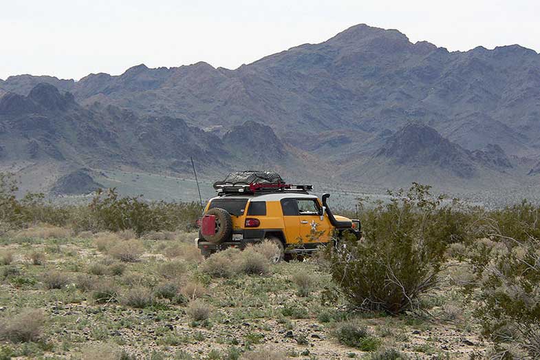

Equipment is especially crucial if you’re riding in a regular SUV without any modifications. We advise correct tires and recovery equipment to make sure you can cross some of the tougher sections.
Another potential “enemy” can come in the form of cacti – like the deceptively named Teddybear Cholla. Its spines can puncture your tire’s sidewall, one more reason to have at least one spare. You should also bring a compressor, a tire repair kit, and a can of flat repair.
Finally, it is often recommended to travel with two vehicles again if you might get stuck or stranded.
How Long Does It Take to Cross the Mojave Road?
It depends how long you want to spend on the Mojave Road Trail, but you can travel the full length of it in 2-3 days. Of course, you can take detours and visit landmarks (more on that below).
Mojave Road Landmarks You Don’t Want to Miss
Riding along the Mojave Road is like going back in time to when the pioneers were first crossing it, as most of it is in the same condition as during that period. The road goes from watering hole to watering hole, crossing the desert, and there are some great stops along the way:
- The Colorado River at Beale’s Crossing is mile 0 and became the site of Fort Mohave.
- Beaver Lake – now a desert and farmland, formerly a lake – the trail cuts through it.
- Piute Creek – with a natural spring that forms an oasis with trees and plants – at mile 23
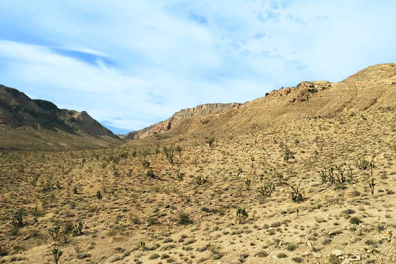
- Joshua Tree Forest – from mile 47, the road becomes narrow in Lanfair Valley, and you cross a thick forest.
- Rock Spring – the biggest watering hole on the Mojave Road, with big boulders and an old cabin at mile 49
- Cedar Canyon – the highest point where you drive up to 5,000 ft elevation as you cross the Mid Hills
- Mojave Road Mail Box – a solitary flagpole where you can sign your name to leave a mark on the trail (mile 74)
- Seventeen Mile Point – a mountain at halfway between Soda Spring and Marl Spring, and also the site of Seventeen Mile Point mining camp
- Soda Lake – a vast dry lake from where the water evaporated, leaving alkaline evaporites of sodium bicarbonate and sodium carbonate. This is a tricky spot where a lot of standing water can gather in the winter, creating another potential Mojave Road water crossing. To avoid driving through water, you may need to take a detour here, or at least proceed with caution. You should also be extra careful not to get stuck in sand if it’s too dry!
- Soda Springs and Zyzyx – the natural spring gave its name to the Tonopah and Tidewater Railroad station that used to pass here. You can find the remnants of a wagon road stop and railroad artifacts, as well as evaporative salt mining and salt flats. As for Zyzyx, the name was made up in 1944 by Curtis Howe Springer, who claimed this was the last word in the English language. He established the Zzyzx Mineral Springs and Health Spa here, and he would fill up water bottles from the spring and sell them to travelers through the desert. In 1974, the land was reclaimed by the government.
- Sand Dunes – play on some soft dunes at mile 106
- Afton Canyon – this is a particularly scenic section with a riparian habitat restoration area and steep walls – from mile 116
- Mojave River Crossing – mile 121, as explained below
- Manix Wash – the exit location of the old Mojave Road (mile 133)
- Fork of the Road – the point where the old Mojave Road split off from the route of the Old Spanish Trail east of Yemo – mile 147
- Drum Barracks – the end of the trail, where you’ll find a Civil War Museum.
The Mojave Road trail is also stunning for its natural diversity, despite being in the desert. You’ll find desert paintbrush, creosote bush, yucca, cholla, and prickly pear cacti out there, and the colors can range quite a lot when they’re in bloom. The most iconic of all plants on the Mojave trail is the Joshua tree, with contorted trunks covered in furry coating and pom-pom-like foliage.
Look out as well for coyotes, rattlesnakes, tortoises, bats, hawks, and other desert animals.

Mojave Road Water Crossings
The water level rises in two places along the Mojave Road in Afton Canyon from time to time. This can make for a spectacular water crossing adventure – depending on how comfortable you feel driving through it! There have been reports of water going as deep as 30 inches.
There is a reference of these two points in the Mojave Road Guide at miles 120.5 and 121.5. You can detour from these points if you’re coming from the east, by taking the Basin Road right at mile 114.8 and re-routing via the Mojave Freeway.
Conclusion – Why Drive the Mojave Road Trail?
Unlike other desert crossing trails that were eventually paved, the Mojave Road has remained lost in time as other routes were prioritized for regular driving in the area. This makes it a unique off-roading destination, as very little development or maintenance of the original trail has been done. This keeps it authentic, more challenging, and a great experience to drive on. It’s one of America’s ultimate wilderness adventures: no shops, no services, no signs, and no motels, and sometimes not even another person in sight!
Kris is an avid off-roader and outdoor enthusiast who loves to brave the elements and take on challenging terrain. He also enjoys sharing his passion and knowledge with others so that they, too, can appreciate the ride.
About Kris