Imogene Pass is a must-see when off-roading in the Rocky Mountain State. It is known for its association with the infamous Black Bear Pass and being a venue where enthusiasts can test their mettle. In this article, let’s discover how its tricky dirt roads and rewarding views make the perfect haven for many adventurers.
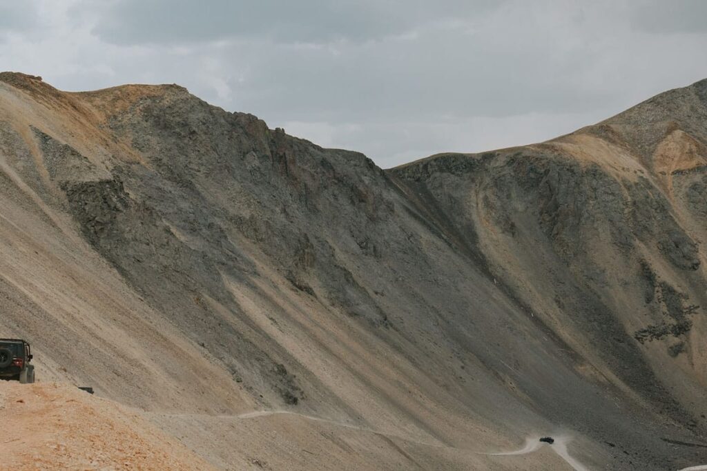
Imogene Pass is a 17.1-mile dirt road that spans the San Juan Mountains. With steep inclines and challenging switchbacks, it was once used as a supply route in the late 1800s but is now revered as a paradise by hikers, runners, and off-roading enthusiasts.
With rocky terrain, steep grades, lack of guardrails, and the occasional inclement weather shaping its ever-changing terrain, this unadulterated landscape has become a haven for thrill-seeking individuals wanting to test their limits and surpass their personal bests. Want to learn more about what Imogene Pass has to offer? Read on.


The Holy Grail of Colorado Trail Runs
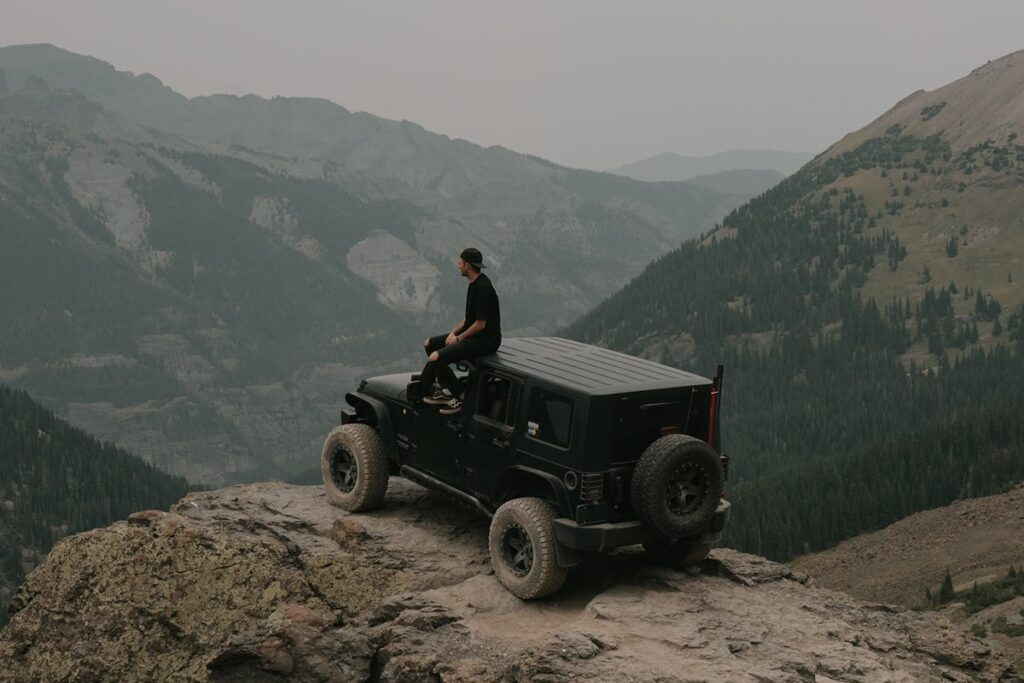
A backdrop as unreal as the many settings of the LOTR trilogy, Imogene Pass is part of the region’s Alpine Loop and among the infamous high-country passes in Western Colorado. Alongside Engineer, Poughkeepsie Gulch, Ophir, and Black Bear Pass, this trail is considered a paradise by not only endurance athletes but also skilled Jeep enthusiasts.
By ‘skilled,’ I mean seasoned drivers — newbies and less experienced off-roaders will not fare as well on this very technical OHV route. There is no such thing as ‘testing one’s luck’ on this trail, as Imogene Pass is very exacting and unforgiving (on-road mistakes can be very costly, if not fatal).
This 17.1-mile stretch is both grueling (for runners) and notoriously difficult — with steep inclines, narrow paths, and rocky terrain. The route gets even more challenging with sudden thunderstorms, snow, and hail.
Despite its difficulty, serious off-roaders continue to gravitate towards Imogene Pass for the breathtaking panoramic views and transformative experience.
History
Imogene Pass was first constructed in 1880. Built by hand, the pass served as a vital transportation and supply route during the late 1800s mining boom for the towns of Ouray and Telluride. The first-ever AC long-distance power line was also installed here, delivering electricity that assisted Telluride mining operations.
Some sources say the name of the mountain pass is dedicated to Imogene Richardson, wife of mining tycoon and Camp Bird Mine owner Thomas F. Walsh. Imogene is said to have been the first non-native woman to climb the pass (hence, having the route named in her honor). Meanwhile, others claim it pertains to his daughter Imogene, widely known as an avid hiker in the area.
Initially, the OHV route was only accessible on foot or horseback. It was not until 1899 that Thomas F. Walsh broke the mold by successfully navigating his steam-powered Locomobile up the pass.
Sadly, the use of Imogene Pass for transportation purposes waned significantly with the decline of the mining industry in the mid-20th century. Nonetheless, the thoroughfare was reopened for recreational 4WD travel in 1966.
Directions to Imogene Pass


From Bridal Veil Falls (1 hour, 15 mins — 1 hour, 20 mins)
Providing access to the Imogene Pass Jeep Road from the south, this road is steep and narrow but can be driven by high-clearance 4x4s.
To navigate this thoroughfare, head south on CO-145 toward Pandora Lane for about 2.9 miles. Next, turn left onto Ophir Pass Road and follow Co Rd 62 for another 7.3 miles. At this point, you’d have already reached Tomboy Road — continue driving until you turn left onto Savage Basin and then right onto Imogene Pass.
The route I just described takes almost an hour and a half to traverse. If you want to reach Imogene Pass from this point a tad faster, you can opt for Black Bear Pass (approximately 9.4 miles point to point).
The latter is shorter but more perilous due to its steep switchbacks and narrow sections with drop-offs. That said, tread this path only if you are an experienced off-roader with a high-clearance 4WD vehicle.
From Tomboy Road (30 mins — 1 hour)
Also known as Imogene Road #869, this 4.5-mile trailhead is outside Telluride and provides access to the Imogene Pass Jeep Road from the north.
It starts at the south end of the town (Savage Basin) and climbs up to the crest of Imogene Pass at an elevation of about 11,500 feet before intersecting with Imogene Pass Road at the peak. It is named after the ghost town of Tomboy, one of the previously thriving mining communities in the area.
This 4×4 road can be easily confused with Imogene Pass because both roads are connected and often used as a single travel route between Ouray and Telluride. So unless you are speaking with locals, folks may be referring to the entire route encompassing Tomboy Road and Imogene Pass Road when referring to Imogene Pass.
From Yankee Boy Basin (45 mins — 1 hour)
Located outside of Ouray, Yankee Boy Basin is a popular starting point for hikers and off-road enthusiasts en route to Imogene Pass. You drive on Million Dollar Highway for approximately 0.3 miles before heading south toward Silverton.
Once you approach the bend or junction, turn south onto County Road 361 (a.k.a. Camp Bird Road), look for the signs “Camp Bird Mine,” “Yankee Boy Basin,” and “Box Canyon Falls,” and continue up the road until you reach its peak elevation of 12,500 feet at Mount Sneffels trailhead (characterized by narrow shelf-blasted roads). Continue to navigate steep grades and switchbacks before taking the left road at 6 miles to get onto Imogene Pass.
From Camp Bird Road (30 mins — 1 hour)
Situated south of Ouray, this route provides access to the Imogene Pass Jeep Road from the west. The Upper Camp Bird Trailhead, in particular, can be accessed via a turnoff from Million Dollar Highway and onto County Road 361. The road can be navigated either by hiking or driving a high-clearance vehicle.
Camp Bird Road is an exciting and challenging route that becomes more interesting as you progress. The road starts as a graded dirt path but quickly transforms into a bumpy shelf road.
As you continue, the road becomes tamer but with rough, rutted sections. The steep inclines on this segment are narrower than most of the route, which makes passing other vehicles close to impossible.
Other Roadways with Access to Imogene Pass
- Forest Road #648 (Black Bear Pass Road)
- Forest Road #823 (a.k.a. Camp Bird Road — intertwines with Red Mountain Pass)
- Forest Road #853 (a.k.a. Bonis Creek Trail)
- Forest Road #638 (a.k.a. Last Dollar Road, McPhee Road — provides access to the pass from the east)
- Forest Road #679 (a.k.a. Ophir Pass Road — provides access to the pass from the north, with a narrow half-mile section rated as moderately difficult)
- Jud Wiebe Trail (starts in Telluride near Mountain Village and has a moderate-to-difficult trail rating)
- Bear Creek Trail (same starting point as Jud Wiebe but follows the Bear Cree drainage all the way to the pass)
- Sneffels Highline Trailhead (starts near Telluride and extends into the 16,587-acre wilderness on the Uncompahgre National Forest)
Given a speed of 10 mph (16 km/h) and barring complications brought about by traffic, weather, and road conditions, the duration of driving from any of these additional points to Imogene Pass would approximately take 45 minutes to 2 hours. However, driving non-stop from Ouray County to San Miguel County would roughly take 2.5 to 3.5 hours, according to Dangerous Roads.
Trail Difficulty

As established so far in this guide, the trail difficulty of Imogene Pass is not one to be taken lightly. As such, below are its trail sections, their approximate length in miles, and tips on how to navigate them:
Oak Street, Telluride to Tomboy Road (Length: 4.5 miles)
The initial stretch of the trail is a narrow and rocky road that demands cautious driving to avoid scraping the vehicle or getting stuck in deep ruts. It has steep inclines and tight switchbacks and is marked as the most demanding part of the trail, classified as “extremely difficult.”
Off-road enthusiasts generally use a low gear and differential lock — on top of advanced driving techniques and choosing lines carefully — to maintain control and grip in this segment of the pass.
Tomboy Road to Imogene Pass Summit (Length: 4.5 miles)
Although less challenging than the first, this section still requires skill and caution and offers stunning mountain views as a reward. It features rocky terrain and some steep grades and is given a difficulty rating of “moderate.”
This particular segment requires a vehicle with good clearance and considerable engine power. Due to large rocks and steep drop-offs, drivers may need a winch or spotter to navigate the section safely.
Imogene Pass Summit to Camp Bird (Length: 5.5 miles)
Descending from the summit of Imogene Pass to the Camp Bird Mine area, it is argued by some off-roaders as the most challenging and technical part of the trail.
Featuring narrow switchbacks, loose rocks, and steep grades, this segment requires precise steering and throttle control and is rated “difficult.” It encompasses both Upper and Lower Camp Bird areas, with the latter situated at the bottom of the descent from the pass summit.
Lower Camp Bird to Ouray (Length: 6 miles)
This 4th and final section of Imogene Pass showcases a mix of challenging terrain and scenic views. But of the four trail sections, it is the most manageable and given a rating of “moderately difficult” (“easy” by veteran off-roaders).
Descending to the town of Ouray, drivers are greeted with creek crossings, steep grades, and rocky terrain requiring low gear, differential lock, and careful maneuvering.
Best Staging Areas
The best staging area on Imogene Pass is in Ouray County, specifically the trailhead on Camp Bird Road. Aside from a large parking lot, it has plenty of room for trailers and is situated in town. The town of Telluride and Tomboy Ghost Town are also great choices and offer equally spacious parking spaces.
Seasoned drivers strongly advise those new to the area to start in Telluride, as it is easier to head downhill when on steep sections of the pass. Conversely, more experienced off-roaders (or unlicensed OHV owners) can take on the route from the opposite end of the trail.
Should you wish for your driving experience to be more demanding but memorable, you can tread the Black Bear Pass — Imogene Pass Loop. But be sure to research thoroughly and plan ahead.
Camping & Reservations
Thistledown Campground near Weehawken Trailhead in the Ouray Ranger District is perfect for off-roaders and hikers, with nine heavily used sites at $10/night. No services or water are available, and proper food storage is required due to bear habitat.
The same goes for Angel Creek Campground, another dry-tent spot in Norwood Ranger District with two vault toilets, a peaceful atmosphere, and 15 sites at $10/night.
As for ATV trails, the majority run through the San Juan National Forest, where free camping is permitted. However, private properties along the way do not allow camping, indicated by clear markings.
Finding suitable campsites on the Telluride side can be difficult, but the Ouray side near Camp Bird and Imogene Basin offers the best free camping options.
Events and Attractions
The Telluride Offroad Adventure Rally
Taking place in the late summer in Telluride, this annual ORV event features guided trail rides, skills clinics, and social events that bring off-road enthusiasts from all over the country together. Guided trail rides include Imogene Pass in its itinerary.
The FJ Summit
An annual event for Toyota FJ Cruiser aficionados, this summit features trail rides, technical workshops, vendor exhibitions, and social events that take place in the San Juan Mountains. Imogene Pass is among the iconic trails that participants navigate during the event.
Needless to say, the ultimate off-roading enthusiast does not confine recreational activities to 4WD-related events. As a matter of fact, most adventurers who visit Imogene Pass frequent it for 4×4 wheeling and endurance runs.
Imogene Pass Run
A point-to-point race spanning the full length of the mountain pass, it is among the most popular trail runs in the region. This race is held annually in September and is considered one of the toughest mountain runs in the U.S.
Hardrock Hundred Endurance Run
Starting and finishing in Silverton, Colorado, this 100-mile ultra-marathon has been held in early July every year since 1992 and is another highly-coveted achievement by endurance athletes. This annual run is considered one of the most challenging ultra-marathons in the world.
Other popular sports and off-roading events in the area are as follows:
- Telluride Mountain Run
- Ouray 100 Gravel Grinder
- Imogene Pass Off-Road Half Marathon
Guidelines
Visit the USFS and Colorado Parks and Wildlife website for guidelines and information on registering your OHV.
Hours Open
The Imogene Pass Jeep Road is typically open 24/7 from late May to early October (given ideal weather and riding conditions). Not all trailheads and forest roads leading to it have similar schedules. Tomboy Road, for instance, has its open season in July — meaning you may have to change starting trailheads if you plan to traverse Imogene Pass outside of this month.
You can find an Imogene Pass OHV map at any district visitor center or online at the United States Forest Service (USFS) Motor Vehicle Use Map (MVUM) website. Should you wish to grab your map in person, most visitor centers in the area are open from 8:00 AM to 5:00 PM daily (or from Memorial Day through Labor Day).
Restrictions
Per San Miguel County regulations, unlicensed OHVs (ATVs included) are prohibited on the first 2.5-mile segment of the road from Telluride to the intersection with Marshall Creek. Unlicensed OHVs originating from the Ouray side of Imogene Pass must turn around once reaching the restricted segment.
In terms of permitted wheelers, Imogene Pass is RV-friendly so long as the vehicle length does not exceed 300 inches. But realistically, it can be quite precarious (not to mention nerve-wracking) driving an RV in these trails — especially in sections with steep drop-offs and little to no guardrails. Hence, you may want to proceed with caution should you decide to bring your RV to save on lodging expenses.
What to Expect

Enthusiasts who have visited Imogene Pass have provided a variety of feedback, most of which are positive and focus on the area’s challenging terrain and scenic beauty. Nonetheless, there are customer insights on weather conditions, crowds, and congestion (more so when annual events or vehicle competitions are held).
Customers love the scenic beauty of Imogene Pass, with spectacular views of the San Juan Mountains and valleys. Meanwhile, its challenging terrain requires high-clearance 4-wheel-drive vehicles and experienced driving skills.
While frequenters enjoy it as a thrilling adventure, others may feel intimidated — especially during peak season when crowds and congestion take away from the solitude of the area.
As for the weather, it is often unpredictable and can change quickly with snow, rain, or fog. Summer thunderstorms and other adverse weather conditions may obscure views or make driving difficult.
Moreover, the fact that Imogene Pass is above the timberline with little protection from the weather does not help. All these factors (and more) are why taking on Imogene Pass warrants a suitable 4WD vehicle and experience.
Conclusion — Imogene Pass Trail Guide
Whether you’re an experienced off-roader or a first-time visitor, I hope this guide is a valuable resource for navigating Imogene Pass safely and effectively.
Following safety and environmental guidelines here, in the guidebooks, and on the official USFS website will give you a transformative, thrilling experience riding this thoroughfare.
Enthusiasts who want to level up will find the Black Bear Pass — Imogene Pass Loop a worthwhile adventure. Otherwise, the Imogene Pass is more than a joy to ride.
Kris is an avid off-roader and outdoor enthusiast who loves to brave the elements and take on challenging terrain. He also enjoys sharing his passion and knowledge with others so that they, too, can appreciate the ride.
About Kris